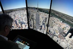
Aerial photography has been around since the 1800s, when images were captured from balloons. After contractors began using aerial photography to record construction progress, architects found they could show a proposed design as it would look in context with its actual surroundings by overlaying an artist’s rendering onto the aerial photograph of a proposed site. Now, we have all kinds of construction-site cameras to record construction progress (according to some authorities, we soon will have drones to take our construction-progress photos), and architects can use satellite imagery, such as Google Earth, to show clients how their proposed design will look in relation to surrounding buildings and land features.
HVAC professionals can use Google Earth and similar products to look at the size and condition of mechanical equipment on the roof of a building or determine the best place for a crane lift. Depending on the location of a building, pixel resolution down to 50 cm (approximately 20 in.) is possible. When used with three-dimensional maps and modeling software, satellite imagery can provide reasonably accurate building details long before a site visit is made.
In our industry, I believe the real value of satellite imagery will be geographic-information-system (GIS) mapping. GIS can locate objects by tracking geographic coordinates transmitted via satellite. They can assemble, store, manipulate, and display geographic data and be used for tasks such as specifying building locations and scheduling inspections. Here in Broward County, Fla., when the ePermit system and GIS are fully integrated, a permit applicant can enter the address of a project (or other location data) and see a map establishing a link between the GIS point and ePermit application.
There is more to GIS than mapping. They can be used to identify areas where construction is impossible, aiding surveying efforts, resource allocation, and site-related decision making. Facilities managers can use GIS to manage infrastructure, underground utilities, and facilities inventories.
So, what is the next step in geospatial technology for the HVAC industry? Earlier this year, a University of Wyoming student was awarded a scholarship from the American Public Power Association to develop a method of tracking and documenting historical data, current configurations, and future equipment needs for the HVAC system in Gillette (Wyo.) City Hall. The student created a GIS-based inventory of equipment and cataloged the equipment’s precise location within the building. The inventory has links to information about each part of the system, including equipment type, make, model, installation date, expected lifetime, and estimated replacement cost.
Systems like this will provide data that can be used to support maintenance, repair, and replacement decisions. And it certainly will make my job as energy auditor and green-building-certification consultant easier.
About the Author
Larry Clark
A member of HPAC Engineering’s Editorial Advisory Board, Lawrence (Larry) Clark, QCxP, GGP, LEED AP+, is principal of Sustainable Performance Solutions LLC, a South Florida-based engineering firm focused on energy and sustainability consulting. He has more than two dozen published articles on HVAC- and energy-related topics to his credit and frequently lectures on green-building best practices, central-energy-plant optimization, and demand-controlled ventilation.

